Brandywine Falls Provincial Park, Whistler British Columbia
- Donna Yewchin
- Oct 17, 2025
- 3 min read

Directions from Vancouver
Start in Vancouver
Take Highway 1 (Trans‑Canada / BC Highway 1) north / east toward the Lions Gate Bridge eventually connecting to Sea-to-Sky Highway (Highway 99) northbound.
Follow Highway 99 (Sea-to-Sky Corridor)
Continue north along Highway 99, passing through Squamish and onward toward Whistler. As you drive between Squamish and Whistler, watch for signage for Brandywine Falls Provincial Park. From Squamish, it’s about 47 km north on Highway 99 to reach the park (after passing the Garibaldi / Daisy Lake areas).
Parking & Trailhead
Park in the designated lot. The trailhead is accessible directly from there.
Note: the lot fills up on busy summer weekends; there is no overflow parking. Do not park illegally along the highway (you risk towing).
Estimated Travel Time - From Vancouver, typical drive time is about 1 hour 30 minutes
About the Hike: The hike to the main viewpoint is easy, suitable for most fitness levels. It takes about 10–20 minutes one‑way from the parking lot to the first viewing platform. The trail is wide, mostly flat, and well maintained.
Side Trails & Alternative Routes
Trail | Distance / Difficulty | Features / What to Expect |
Swim Lake Trail | Short, with one steeper section. Rougher terrain than the main trail. | Branches off just before crossing the railway. Leads to a small forest lake. No beach, no formal facilities; swimming is possible but conditions basic. |
Sea‑to‑Sky Trail | About 1.5 km (one short section) beyond the falls, suitable for both hiking and biking. Moderate in parts due to some steep sections. | After the railway crossing, this trail heads NE toward the Whistler Bungee Bridge over the Cheakamus River. Along the way you’ll get different views (lakes, canyon, vistas), open sections under powerlines, etc. |
Lava Lake Trail | Approx 2.7 km roundtrip from the covered bridge; moderate. | Starts after the covered footbridge (go left instead of right toward falls). Passes through an unusual pine forest for the coast, some small lakes, and lava‑field terrain. Less used and more peaceful. |
We started our day of exploration with the main trail. From the parking area, we headed towards the quaint covered footbridge. The sturdy beams and rustic wood of the bridge provided perfect peek-a-boo views of Brandywine Creek bubbling and flowing across the stony pebbles below.


We crossed the bridge, making a right turn on the trail. This led us into a sensory experience of delightful scents from the pine trees hovering around us and the cool dampness of the humus pathway.
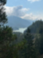
Shortly up the trail we cross the Canadian National railroad tracks. There were a few forest fires burning across BC causing the sky and surrounding area to be a bit hazy.

A short distance up the trail we heard the roar of the falls as we arrived at the viewing platform.
The wooden viewing platform offered ample spots to take some pictures or enjoy the spectacular view.
We spent about 20 minutes clicking off pictures before returning to the railroad tracks in search of the Sea-to-Sky trailhead. We planned to hike the 1.5 km trail within the park, leaving the 107 km (give or take) main trail from Squamish to Pemberton for another day.
The trailhead was just past the railroad tracks leading NE towards the Whistler Bungee Bridge over the Cheakamus River. Along the way we caught a glimpse of Daisy Lake off in the distance.
We ventured further along the path into the forest, where small marshes were concealed. I looked for any indications of wildlife but found none.

Walking along the ridgeline, it felt as if we were treading on pavers due to the way the stones were arranged across the trail.


Through the trees, I caught sight of the Trans-Canadian Rail.
Departing from the natural paved path, we found ourselves in a moss-covered wonderland. The rocky cliffs were draped in moss from the dense red alder trees, which blocked the sun and offered shade on warm summer days.

As we proceeded along the trail, we made our way up the side of a cliff.


From the cliff's summit, the river was completely visible. The water's strength was evident as white, foamy caps formed on its surface.
In just a few minutes, the Cheakamus Bridge came into view. Although there wasn't a bungee jumper, the ramp was visible, suspended above the rushing river.

A film crew was stationed on the bridge. The crew was at lunch, so we didn't get to see any filming. One crew member told us they were preparing for a bungee jumping scene. We would have loved to stick around, but it was getting late, leaving us no option but to continue our hike.


After exploring around the bridge, we decided to head home and leave further exploration for another day.