Tom's Thumb Trail & the Overlook Trail
- Donna Yewchin
- Feb 15, 2019
- 3 min read
Updated: Feb 20, 2019

Tom's Thumb trail is located in the McDowell Sonoran Preserve. This trail plus the Overlook trail is a 5.6 mile heavily trafficked out and back trail located in North Scottsdale, Arizona. The trail starts at a elevation of 2,805 and end at 3,830. Your elevation gain while hiking will be 1,025. You are rewarded with beautiful wild flowers and rock formations. The hike is rated as difficult.
Hiking Tips: This trail becomes increasingly narrower with loose gravel on the switchbacks.
It's much easier doing this hike with the proper gear. I recommend hiking poles, hiking shoes with good tread and plenty of water.
The trail leading up to Tom Thumb Mountain is flat and meanders through the desert for about a quarter mile. Hiking along daydreaming I started wondering who was Tom Thumb and why is this mountain named Tom Thumb when the character was as tiny as a person's thumb.

After I hiked up through several of the switchbacks and look back down the trail, my question was answered. The hikers behind me looked like tiny little fairies just like Tom Thumb.

For about a mile you'll be traversing through switchbacks arriving at the first scenic overlook, Raven Roost.


Raven Roost is perfect for taking a break, soaking in the view and searching for ravens. The day I hiked a group of friends was resting talking about the three ravens that were diving in and out of the bluffs. Unfortunately I had just missed them.
Already poppies are popping up among the Teddy Bear cholla in late January.

Arizona wildflowers normally make their showing in March but this year with all the rain it's a bumper crop year.
The sun was shining brightly on the eastern side of the trail lighting up the teddy bear chollas blanketed by boulders and fully opened yellow poppies.

As you keep going along the trail the switchback's become narrower with loose gravel. This is where your hiking poles really come in handy. Stopping at the Vulture scenic overlook, I took a peek back down the trail and it was sprinkled with hikers tiny as Tom Thumb. This photo provides a glance of the elevation gain you'll be climbing.

After a few more switchback you arrive at the area where the hike now continues through rolling hills with scenic views across North Scottsdale and Fountain Hills.

Pinnacle Peak, another popular hiking destination is frame beautifully by the other mountains flanking it's right and left side.
The next scenic overlook provided a beautiful view of Fountain Hills Park. I was lucky enough to arrive to see their famous fountain going off.

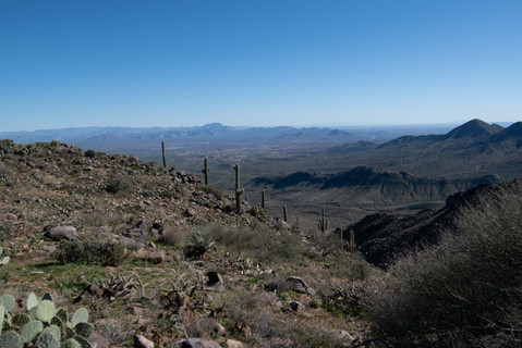
This juncture of the hike felt like I was walking on a cloud. It could have been the elevation gain or views with wide-open space, but it was one of my favorite parts of this hike. Strolling past boulders lining the trail and


walking through the boulder tunnel was a good respite from the switchbacks. Pausing briefly, I turned around and took a panoramic picture of the landscape.

Continuing my journey, I hiked another ½ mile and caught a glimpse of Tom Thumb Peak. I'm sure the real reason this hike is called Tom Thumb is because the peak looks just like a giant thumb.
You can turn left towards the peak or continue straight to the Overlook Trailhead. Today we turned and hiked another ¼ mile to the peak and soaked in the expansive view below. The trailhead a pinpoint below put a smile on my face.

Now it was time to check out the Overlook trail. This added another mile to the hike, but the views were worth it.


This part of the trail isn’t well traveled so it’s a perfect spot for some quiet time and meditation. Time to head home and hike back out. I recommend this hike, but it could be challenging for folks new to hiking in this area. Good Luck and Happy Trails!